myAIP VFR 1.73.08
Continue to app
Free Version
Publisher Description
myAIP VFR - Application for preparation and, GPS flight tracking, of your VFR flights
myAIP is an all-in-one application to assist plane pilots in preparing VFR flights in France and in a large part of Europe!
It provides all the information and aeronautical safety for VFR flights with:
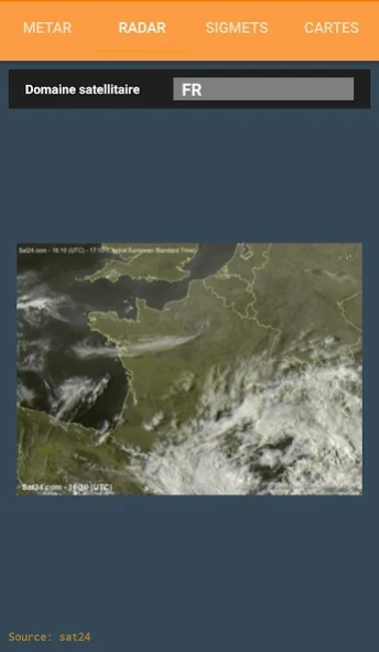
✔ TAF, METAR, SIGMET, raw and decoded (worldwide)
✔ Weather radar
✔ WINTEM and TEMSI maps (France and Europe);
✔ Import your own maps or from Editerra Air Million, CartaBossy, IGN, openFlightMaps, ... (formats: ECW, GEOTIFF, MBTILES)
✔ NOTAM for airfields et FIR (worldwide);
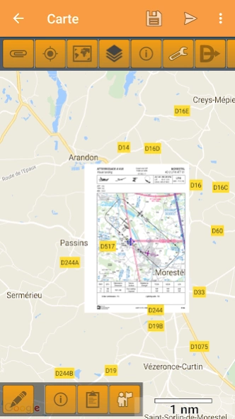
✔ Display Visual Approach Charts VAC, with updates following Airac calendar;
✔ BaseUlm charts (France only)
✔ Display AIP Supplements (France only);
✔ AZBA aeras for military activity (France only);
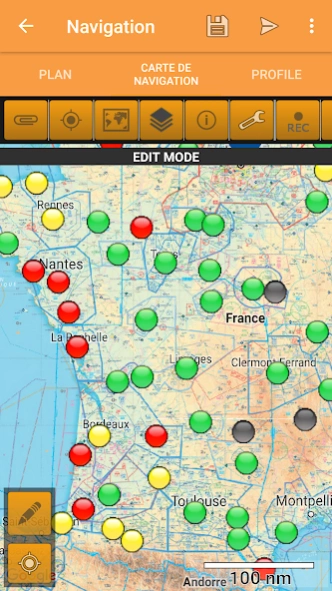
✔ In-flight alerts for airspace, minimum altitude and descent rate;
✔ Manage favorites and offline data.
✔ Map overlays included (France, Spain, Italy, Benelux, Germany, Switzerland)
Create your flight plan simply and quickly,
✔ Updated Google Map.
- Many airfields across Europe (France, UK, Germany, Italy, Spain, Belgium, Netherland, Norway, Sweden, ...)
- Beacons NDB, VOR, VOR-DME et TACAN,
- Automatically look for the closest airfield to your flight path.
✔ Vertical altitude profile with airspace projection and ground level,
- altitude can be modified simply by draging waypoints on the graphic, or with edition of the flight plan,
- accurate ground elevation retrieved from a digital elevation model,
✔ Help defining radionavigation parameters ;
✔ Automatically find nearby airfields;
✔ Summary of the collected information for your flight in one single pane;
✔ Send all the collected data (package ZIP) to your email for printing;
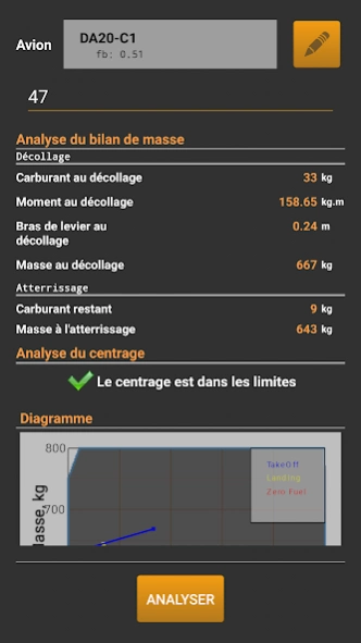
✔ Aircraft (DR300,DR400-{120,140,160,180},DA20,DA40,C152,C172,TB10)
✔ Weight an balance
✔ Fuel budget
✔ Export flight plan to GPS Exchange .gpx
✔ Export flight plan, fuel budget and weights balance to PDF file
And more,
✔ the project file can be stored on the cloud for an access from any of your devices
✔ VACs are cached for offline access (in your Download directory)
✔ You can update information in the database and share it with other users of myAIP!
✔ You can add in the database your own waypoints for easy reuse in future flight plans;
✔ Works on tablets (preferably) and phones!
About myAIP VFR
myAIP VFR is a free app for Android published in the Geography list of apps, part of Education.
The company that develops myAIP VFR is JTO. The latest version released by its developer is 1.73.08.
To install myAIP VFR on your Android device, just click the green Continue To App button above to start the installation process. The app is listed on our website since 2024-01-27 and was downloaded 14 times. We have already checked if the download link is safe, however for your own protection we recommend that you scan the downloaded app with your antivirus. Your antivirus may detect the myAIP VFR as malware as malware if the download link to com.jto.android.olivia is broken.
How to install myAIP VFR on your Android device:
- Click on the Continue To App button on our website. This will redirect you to Google Play.
- Once the myAIP VFR is shown in the Google Play listing of your Android device, you can start its download and installation. Tap on the Install button located below the search bar and to the right of the app icon.
- A pop-up window with the permissions required by myAIP VFR will be shown. Click on Accept to continue the process.
- myAIP VFR will be downloaded onto your device, displaying a progress. Once the download completes, the installation will start and you'll get a notification after the installation is finished.
